

Starting from the mountain BRAUNECK west of the city of
LENGGRIES you can realize a wounderful ridge-hiking tour on the
path 451 to the Benediktenwand which can be reached within about 4
hrs. But first a warning: During the first hour of hiking you pass
some commemorial plaques/-crosses where you will see that those who
died had been hit from flashes of a thunderstorm. So in any case it
will be wise to start the tour only when the weather is safe of
thunderstorms. There are some distances where there is no way down
from the ridge where the danger is great!
To come up to the BRAUNECK you can use a cabin-cable-car. This tour
including the way back needs for the most mountaineers more time
than one day only. So it will be reasonable to stay over night at
the mountain hut Tutzinger Hütte and return the next day. (The
hut-keeper will be glad about!)
But lets first go on reaching the first mountain SCHRÖDELSTEIN
which will be by-passed at its southern side. (To climb up is only
for the experienced!)
Then you pass down to a saddle in front of the STANGENECK which
will be reached over a ridge. Furtheron you pass the VORDERER
KIRCHSTEIN and the LATSCHENKOPF. Up to now you have been hiking
about 1 1/2 hrs. Then you go down to the FEICHTECK-saddle and after
hiking over the ACHSELKÖPFE you have been hiking about 3 hrs.
Finally you reach the ROTÖHR-saddle where the path goes down
to the Tutzinger Hütte. But first you want to go up to the top
of the BENEDIKTENWAND which will be reached after annother hour. A
final remark to the ACHSELKÖPFE:
They have not to be passed which could be dangerous especially when
it is wet and the rocks then slippery. You can by-pass them to the
right on their northern flank in western direction.
He/She who wants a more explicitely report with pictures please
have a look on the page "Families a. Children".
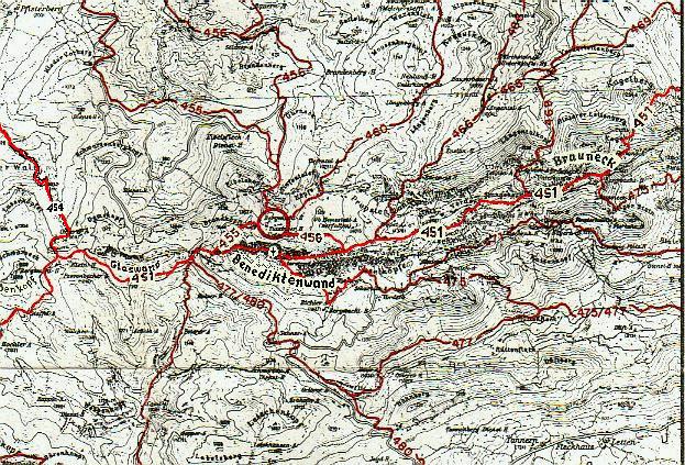
Possible Map Kompasskarte Nr.7 Murnau-Kochel 1:50000